New requirements for farmers for the 2025 harvest following the EU Deforestation Regulation
Background
From December 30, 2025, all soya traded in the EU, as well as relevant products such as soya meal and soya oil, must comply with the new EU Deforestation Regulation 2023/1115 (EUDR). This means that the 2025 harvest must already meet these requirements. Exception: Micro and small enterprises have time until 29.06.2025. Soya that is sold on the EU market before the end of this transitional period does not have to meet the requirements. However, it is currently unclear whether medium and large companies, where the goods are mixed, will require their suppliers to provide all data in accordance with the EUDR despite the exemption in order to be prepared for the entry into force of the requirements..
According to the EUDR, geolocation data must be available for all soya fields. The geodata must be uploaded to a new EUDR information system (EUDR Due Diligence Registry) as part of the Due Diligence Statement (not the same as the Donau Soja / Europe Soya declaration of self-commitment) – otherwise the soya may not be sold on the EU market. Each Due Diligence Statement (DDS) receives a reference number that must be passed along the supply chain.
What does this mean for farmers
EU farmers: As first-distributors, EU farmers must fill out the Due Diligence Statement (DDS) or can, for example, authorise their storage facility to do this. In both cases, the geolocation data of all soya fields must be collected and passed on from the 2026 harvest onwards. (Exception: If farmers fall under the definition of medium-sized or large companies, the soya must meet the requirements from 30.12.2025. Definition of SMEs here: https://www.donausoja.org/de/eudr-infoprozess/)
Non-EU farmers: If soya or relevant products such as soya meal or oil are to be sold in the EU, the geolocation data of the fields must be collected and shared, so that the first-distributor in the EU has all the information for the DDS. For imports by medium and large companies from 30.12.2025, the geodata for the 2025 harvest must be available.
Information for EUDR Due Diligence Statement
In addition to the geolocation data of all fields, the following information must be shared:
-
- Product and quantity: e.g. 1,000 kg of soybeans
- Harmonised System Code for soya (HS Code; in Annex I of the EUDR; see below): 1201
- Country of origin: e.g. Austria
Farmers can declare all their fields, regardless of whether soya was grown on them in the first year or not (so-called “Declaration in Excess”). In subsequent years, the relevant fields can then be selected and don’t need to be entered into the EUDR information system again.
Annex 1 EUDR lists relevant soy products and HS codes as follows:
-
- 1201 Soya beans, whether or not broken
- 1208 Soya bean flour and meal
- 1507 Soya bean oil and its fractions, whether or not refined, but not chemically modified
- 2304 Oilcake and other solid residues resulting from the extraction of soya bean oil, whether or not ground or in the form of pellets, resulting from the extraction of soya-bean oil
Donau Soja / Europe Soya declarations of self-commitment (SVE) and geolocation data
There are various ways for Donau Soja / Europe Soya farmers to pass on geolocation data.
As of harvest 2025 at the latest: EU farmers can share geolocation data in one of the following ways:
-
- Upload to the Donau Soja IT system: In the Donau Soja database, the geolocation and polygon data is marked and saved directly, like with Google Earth. Information including explanatory videos will follow shortly.
- Delivered to the Donau Soja certified first collector: The Donau Soja certified first collector is authorised to fill out the DDS and the geolocation data will be passed on to him.
- Reference number of the EUDR DDS: The geolocation data is entered directly by the farmer into the EUDR information system as part of the DDS and the reference number is stated in the Donau Soja/Europe Soya Farmers’ Self-Commitment Declaration.
Non-EU farmers can share geolocation data in one of the following ways:
-
- Upload to the Donau Soja IT system: In the Donau Soja database, the geolocation and polygon data is marked and saved directly, like with Google Earth. Information including explanatory videos will follow shortly.
- Delivered to the Donau Soja certified first collector: The Donau Soja certified first collector is authorised to fill out the DDS and the geolocation data will be passed on to him.
- In RS-3 countries (Ukraine, Moldova): the geo-coordinates are transmitted directly from the control body to Donausoja.
Information about geolocation data of the cultivated areas
For the 2025 harvest, the geolocation data of all soybean cultivation areas must be determined. (Exception: EU farmers who fall under the definition of small and micro-enterprises).
A geocoordinate consists of a latitude and a longitude value, each with six decimals.
-
- Soya fields < 4 ha: One geolocation data point within the field is sufficient.
- Soya fields > 4 ha: Geolocation data must be collected as polygons = one geocoordinate per “corner” of the field so that the boundaries of the field can be traced (see figure 2).
The geolocation data can be determined using a computer or on site via mobile phone.
DETERMINATION OF GEOLOCATION DATA ON SITE USING A SMARTPHONE
On smartphones with Google Maps or similar applications, the geolocation data can be found as follows:
When you simply click on the corresponding location in Google Maps, a marker is set (red location marker in figure 1) and information about the location including the geolocation data is displayed (yellow marked text in figure 1). Only the order of longitude and latitude must be exchanged from Google Maps to the EUDR information system.
Further information on general use of GPS (German only):
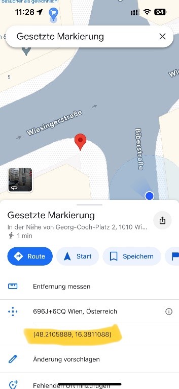
Figure 1: Screenshot of Google Maps demonstrating geolocation data
DETERMINATION OF GEOLOCATION DATA ON PC
As with a smartphone, geolocation data can be found on Google Maps by clicking once on the area.
Using Google Earth he boundaries of the field can be marked and saved as a polygon (see Figures 2 and 3 below):
-
- Click on the blue “chain” at the top of the image (“Add path or polygon”).
- Click on the respective corners of the field and connect them to form a polygon.
- Click on “Save to Project” and save as a KML file.
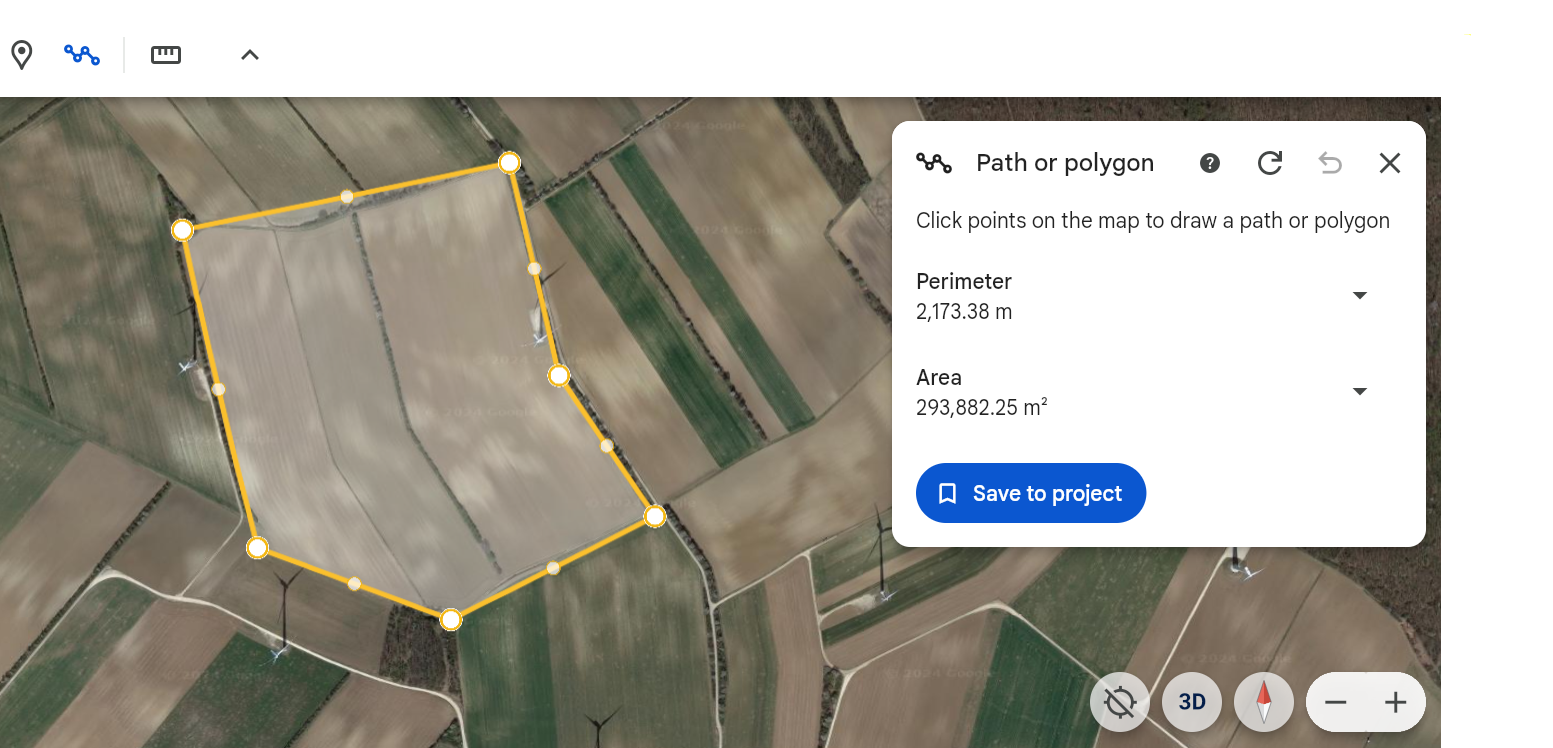
Figure 2: Screenshot from Google Earth demonstrating polygon data

Figure 3: Screenshot from Google Earth demonstrating exporting the polygon data as a KML file.
For more information contact us at sustainability@donausoja.org.